
Monday, September 26, 2011
Volcanic hazard

Falling Glass

Durring an earthquake, glass can fall and cut people. It can cause a lot of damage and deaths.
WOW !

This is a picture of a bus getting crushed by pieces of building after a large earthquake, this is hazardous because it can crush people.


Earthquake
 This is a picture after an Earthquake in California in 1994. Many buildings are not able to withstand the force of an earthquake, so they may collapse, trapping, injuring or killing the occupants.
 Japan damage from aftershock. As you could see in the photo there is huge structural damage

Ooo, Aaa...A Lahar!
 This is a Lahar at Mt. St. Helen's during the eruption of 1982. A Lahar is dan
gerous due to the lava that flows down a path, and destroys everything in its way. Luckily, the lava flows slowly!


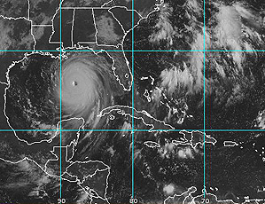
hurricane

this hurricane is hurricane Katrina, scientist would use this to trackwho will get hit hardest.
Valcano
This is an exploding composite valcano. They can use this and study where the lava comes out of for next time.

TSUNAMI

One danger of earthquakes at sea is a tsunami. Tsunamis cause a lot of destruction and death.
Lava bombs
 This is a picture of lava bombs. They can cut right through an object. They can be really big, or really small. They also can destroy buildings, cars, and more. Lava bombs are dangerous to people because they can kill you if they hit you.
Pyroclastic Flow

This is a pyroclastic flow. These type of eruptions can devestate anything in its path. The ash produced from it can change the climate and huge lava bombs are threatening to people.

Monday, September 19, 2011

Downtown Vancouver

This is an air photo of Downtown Vancouver in 1995. It was taken to show the progress of urbanization in Vancouver.

Hurricane Irene
This is a satellite image of hurricane irene. Scientistds could use this to predict where the hurrican will hit next


Air photo-Butchart Gardens

This photo may show the tourists the entire view of the garden (the shape and area); maybe, the desgnier wants to use it to enlarge the garden.
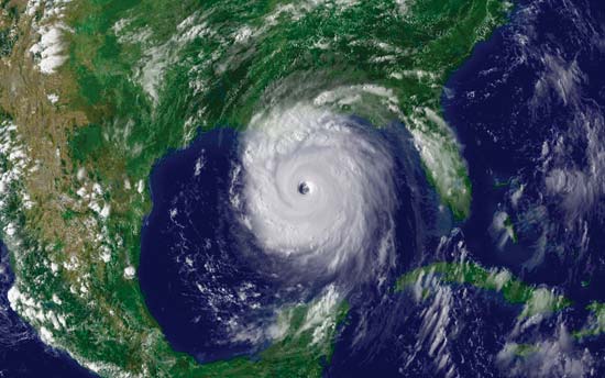
HURRICANE KATRINA
This is a satellite image of Hurricane Katrina from 2005. Scientists might have used this to guess where the hurricane would go next.
Hurricane Irene

This is a satellite image of hurricane Irene. Scientists can figure out where the hurricane might travel next.
Hurricane Katrina
This satellite image is of Hurricane Katrina, which was formed on August 23, 2005. The image can help scientistist better predict where the hurricane is going, the size of it, and what force it has.
Night-time satellite image

This is an image of a night-time satellite image of the globe. This can help anybody to see which country is using the most electicity during evening time!
Subscribe to:
Comments (Atom)